Germany’s most beautiful natural wonders
What a wunderbar world
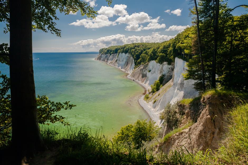
Chalk cliffs, Rügen, Mecklenburg-Western Pomerania
The Bastei, Saxon Switzerland National Park, Saxony
Schrammstein, Saxon Switzerland National Park, Saxony
Schlachtensee, Berlin, Brandenburg
It's for good reason that Brandenburg is known as the land of 3,000 lakes. Berliners are spoilt for choice when it comes to natural beauty spots with leafy Grunewald Forest to the west and a whole host of beautiful water bodies. Schlachtensee is one of the prettiest. Set on the edge of Grunewald, its clean, enticing waters are surrounded by trees and a boardwalk loops around its shores. There's a guesthouse and boats for hire too. It's set between Krumme Lanke and Wannsee, other lovely lakes popular with wild swimmers.
Spreewald, Brandenburg
Thuringian Forest, Thuringia
Known as the green heart of Germany, the central state of Thuringia has many lush landscapes including the largest uninterrupted forest area in Germany. The Thuringian Forest is prime hiking territory with a vast network of trails around its rivers, woodlands, highland meadows, moors and ridges. The most famous of all is the Rennsteig, the country’s oldest trail. It runs for 104 miles (167km) along a ridgeway through the heart of the upland forest from Hörschel to Blankenstein.
Now check out more stunning sights you won't believe are in Germany
The Palatinate Forest Biosphere Reserve, Rhineland-Palatinate
Set in the southwest near the border with France, the UNESCO biosphere known as Pfälzerwald in Germany is a place of thick pine forests, majestic sandstone cliffs (where crumbling castle ruins perch) and vineyards. It’s the only German biosphere reserve with a wine-growing region, the Haardtrand-Weinstraße, and it contains the country’s only sweet-chestnut-tree forest. This fertile land is also home to some rare species including lynx (which were re-wilded here), wildcats and peregrine falcons.
Urach Waterfall, Bad Urach, Baden-Württemberg
The unique karst landscape of the UNESCO Global Geopark Swabian Alb is scattered with stunning natural landmarks. It has the country’s highest density of caves, along with bubbling hot springs and crashing waterfalls. The Urach Falls are the most impressive of the latter. Found in the middle of the Maisen valley, on the edge of Bad Urach, the karst spring drops from a height of nearly 131 feet (40m) and tumbles melodically over moss-covered rocks into the valley below.
Love this? Follow our Facebook page for more travel inspiration
Blautopf, Blaubeuren, Baden-Württemberg
Another unmissable gem in the Swabian Alb region is Blautopf, a luminous blue spring that feeds into the River Blau. Translating as “blue pot”, Blautopf's deep waters get their startling colour from limestone particles and have given rise to many tales over the centuries. The most enduring legend is that a laughless and infertile mermaid was banished here by the Black Sea King. There is a statue of her near the pool. One of the region’s vast underground cave systems can also be entered through an underwater cavern in the pool, called the Blauhöhle.
Saalfeld Fairy Grottoes, Thuringia
Sylt, Schleswig-Holstein
Sand dunes and salty air sum up the scenery on this sliver of an island in the North Sea. Part of the Frisian archipelago and right next to Denmark, Sylt’s long sandy beaches have long drawn holidaymakers and it’s become a seriously stylish seaside getaway. Aside from its glamorous stretches of sand and wildlife-rich salt marshes, one of its most striking natural features is the Rote Kliff. The steep red cliff is on the open sea side of the island between Wenningstedt and Kampe.
The Wadden Sea, Lower Saxony and Schleswig-Holstein
Sylt lies within Schleswig-Holstein's Wadden Sea National Park, one of two national parks in Germany that form part of the Wadden Sea World Natural Heritage Site. As the largest unbroken system of intertidal sand and mudflats in the world, the Wadden extends from the Netherlands along the coasts of Lower Saxony and Schleswig-Holstein and into Denmark. This bleakly beautiful coastal landscape is a unique habitat for many animals and plant species and a critical breeding ground for all manner of fish and seabirds, as well as seals.
Saarschleife, Saar-Hunsrück Nature Park, Saarland
Possibly the most photographed river bend in all of Europe, the horseshoe shape of this loop along the Saar River is picture-perfect. Known as Saarschleife (Saar Loop) in German, it’s near the town of Mettlach. The Cloef lookout gives a wonderful view of the hairpin bend and green hills of the Saar-Hunsrück Nature Park. But for bird’s-eye panoramas, the Saar Loop treetop path, with its 138-foot (42m) tower, is best. The Saar, a tributary of the Moselle, meanders through the lush landscape of Saarland, a small and thickly forested state that borders France and Luxembourg.
The Black Forest, Baden-Württemberg
Wutach Gorge, the Black Forest, Baden-Württemberg
Triberg Falls, the Black Forest, Baden-Wurttemberg
The crashing Triberg waterfalls, which thunder through a heavily forested valley, are another Black Forest must-see. The powerful series of seven cascades, which plunge down to the Gutach River, form one of the highest waterfalls in Germany at 535 feet (163m).
Lange Anna, Heligoland, Schleswig-Holstein
Heligoland, a tiny archipelago that lies off the coast of Schleswig-Holstein, is a fascinating place. It has been passed between Denmark, Britain and Germany over the centuries, and today it mostly draws day-trippers for its seafood and for coastal walks along striking red cliffs and out to its spindly sea stack. Nicknamed Lange Anna, the stack stands at Heligoland's north-west tip and is a nesting place for guillemots, kittiwakes, gannets, fulmars and razorbills. Along with another nearby rock, it's the sight of the so-called guillemot jump every June, when the chicks first attempt to fly.
Externsteine, Teutoburg Forest, North Rhine-Westphalia
The low, forested hills of the Teutoburg Forest, which straddle the states of Lower Saxony and North Rhine-Westphalia, were famously the site of a crushing Roman defeat at the hands of Germanic tribes. Today, its most famous landmark is the Externsteine: strange sandstone columns that tower over the lakes of the Wiembeck valley. Formed during the Ice Age, these ancient landforms are steeped in folktales and they're thought to have been an ancient pagan place of worship, before becoming an early Christian site. The crags feature man-made grottoes, carved steps and a monumental rock relief showing biblical scenes.
The Harz Mountains, Saxony-Anhalt
Lüneburg Heath Nature Park, Lower Saxony
Felsenmeer, Odenwald, Hesse
The cascading rock feature known as Felsenmeer, or Sea of Rocks, is an otherworldly sight within the forested mountain range of Odenwald, in southern Hesse. Part of the Geo-Nature Park Bergstrasse-Odenwald, the giant crystalline boulders appear to pour down the wooded hillside and into the valley. They were formed 340 million years ago when two continents collided and formed the mountains. The Romans used the site as a quarry during the 3rd and 4th century AD – it’s still possible to see some of the ancient ruins.
Hainich National Park, Thuringia
Hainich National Park is home to one of Germany's wild old beech forests, the primeval forests that once swept across Central Europe and are now under UNESCO protection. In fact, the park has Europe's largest coherent deciduous forest – as a former military restricted zone it escaped development. Today an elevated walkway allows walkers to gaze down at the dense canopy of beech trees. Down below, the forest floor is home to many endemic plants (including rare orchids) and fungi, while animals such as the Bechstein's bat and spotted woodpecker flutter about the woods.
The Rhine River, various locations
The mighty River Rhine has to be Germany’s most famous natural landmark, snaking its way from the Swiss Alps all the way out to the North Sea in the Netherlands. The Middle Rhine Valley (or Romantic Rhine) has the prettiest section, running 40 miles (65km) between Koblenz and Bingen. Here the river cuts through the steep Rhenish slate mountains, its banks awash with ravishing scenery: all terraced vineyards, forested peaks topped with castle ruins and ancient riverside villages.
Lake Constance, Bavaria and Baden-Württemberg
Lapping the shores of Germany, Austria and Switzerland, Lake Constance (or Bodensee) is one of the largest lakes in central Europe. Part of the course of the Rhine, the lake formed in a glacier basin. Ringed by the Alps and Black Forest and lined with pretty towns and vineyards, its German shorelines lie in the states of Bavaria and Baden-Württemberg. The calm, island-dotted waters are a hive of water sports, but some of the best views are found along its shoreline – a 167-mile (270km) cycle path loops around it.
Blomberg Mountain, Bavaria
Mount Watzmann, Berchtesgaden National Park, Bavaria
Königssee, Berchtesgaden National Park, Bavaria
Ice caves, Berchtesgaden National Park, Bavaria
The magic keeps on coming in this astonishingly diverse national park. It also has ice caves, including one of Germany’s largest (and the only one typically open to the public). The icy chambers of the Schellenberger lie at 5,150 feet (1,570m) within the Untersberg massif and are at their most beautiful in early spring. Going up the high alpine karst plateau, the hike to the cave is challenging – it takes around two hours from the summit's cable station.
Partnach Gorge, Garmisch-Partenkirchen, Bavaria
Zugspitze, Garmisch-Partenkirchen, Bavaria
Germany’s highest peak, Zugspitze stands at 9,718 feet (2,962m) above sea level. Part of the Wetterstein mountain range in the Bavarian Alps, Zugspitze has three glaciers and is home to the country’s highest ski resort. Its summit – which can be scaled on foot, reached via cable car or on the scenic cogwheel railway from winter sports capital Garmisch-Partenkirchen – commands incredible 360-degree views. It looks over hundreds of other craggy peaks that range across Germany, Austria, Italy and Switzerland.
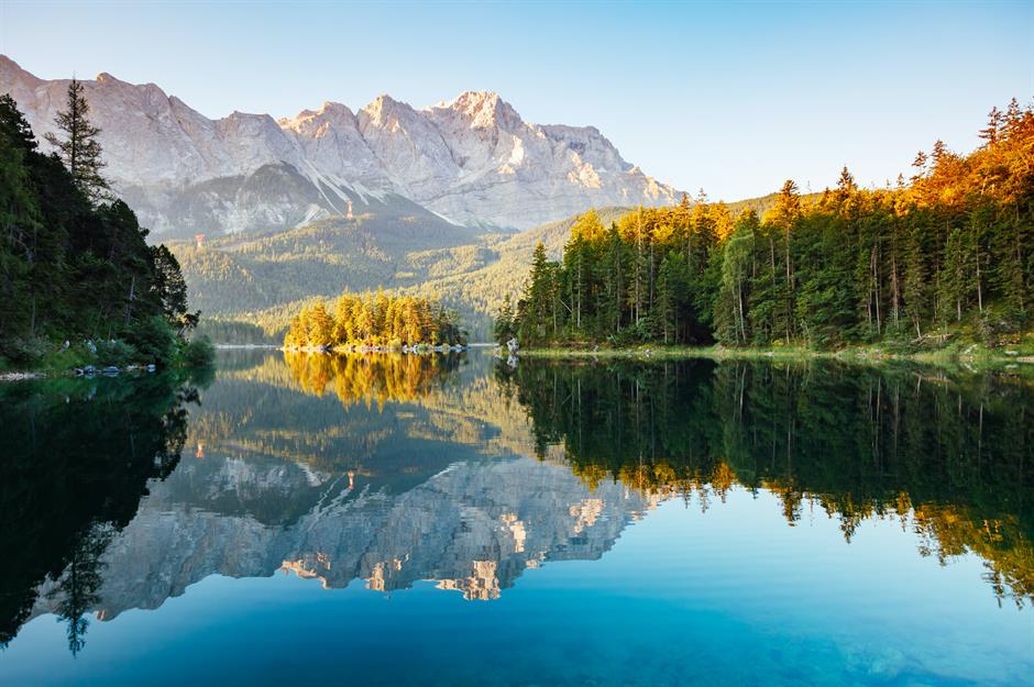
Lake Eibsee, Garmisch-Partenkirchen, Bavaria
At the foot of the mighty mountain lies an ethereal alpine lake called Eibsee. It was created by a gigantic rockslide from Zugspitze nearly 4,000 years ago. Set at an altitude of 3,280 feet (1,000m), the beautiful deep blue lake is surrounded by forest and framed by the craggy peaks of the Wettersteins. A loop trail circuits around Eibsee, leading to some lovely, sheltered bays for swimming, with views across the water and its eight little isles.