Brilliant British pub walks offering breathtaking beauty
Hike your way to delicious food and drink
A refreshing pint or a hearty Sunday roast in a cosy pub definitely tastes better after a rewarding walk out in nature. For all those hikers out there who love ending the adventure in a pub, the National Trust has published 100 Great Pub Walks, a brilliant book filled with nature-packed trails to discover, plus the pubs you'll find along the way. Here are some of our favourites.
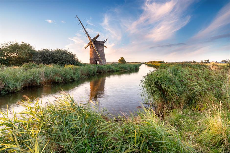
Horsey, Norfolk, England
On this six-mile (10km) walk you'll get to take in the most beautiful views Horsey has to offer, from the still waters of Horsey Mere to acres of blooming meadows. Start the hike with a walk up to the Horsey Windpump, which was built in 1912 and has been part of the National Trust and open to the public since 2019. Make your way past it and you'll reach Horsey Mere, then continue around the northern bank until the path hits Waxham Newt Cut.
Horsey, Norfolk, England
Soon you should spot Brograve Mill, a historic structure from 1771 with a spooky history. A local legend tells of Sir Berney Brograve, the mill's former owner, who hid in its walls after losing a bet with the devil. Beyond the mysterious building, the trail winds its way to the beach where you'll trek past sandy dunes and a shipping container that offers information on the resident Atlantic grey seals. Finally, look out for signs to the Nelson Head, where hard-earned respite awaits.
Seven Sisters, East Sussex, England
Discover the allure of the Seven Sisters while taking on this six-mile-long (10km) trek leading you along the rugged East Sussex coast. Begin your hike in Crowlink, a small village that was famous for smuggling cheap and illegally imported 'Crowlink gin' to bars in London in the 1700s and 1800s. After you explore the charming town, the trail takes you right to the edge of the sea. Join the South Downs Way and slowly ascend Went Hill, where you'll have the most incredible view of the Belle Tout Lighthouse.
Seven Sisters, East Sussex, England
You can go directly to East Dean or linger to take a closer look at the lighthouse. Built in 1832, it's lived many lives but, most notably, was owned by the BBC who used it as a filming location. Stop here to take in the stunning panorama too. As you head into East Dean towards The Tiger Inn, there's a war memorial as well as a cottage adorned with a blue plaque, claiming to be Sherlock Holmes' retirement location. Then it's time for a pint and a pie.
Love this? Follow our Facebook page for more travel inspiration
Dunstanburgh Castle, Northumberland, England
Hike up to Dunstanburgh Castle and travel back in time with this pub walk weaving through some of Northumberland's most picturesque corners. Begin your eight-mile (13km) journey at Craster Quarry car park and head downhill towards the charming fishing harbour, Craster, which was once the ‘kipper capital’ of Britain. On your way up, you'll scale verdant hills while enjoying amazing views of the wild North Sea – you might even spot a seal.
Dunstanburgh Castle, Northumberland, England
As you arrive at Dunstanburgh Castle, take a moment to marvel at this imposing ruin, built between 1313 and 1322. Continue your walk round it and try to spot the distinctive rock formation known as Greymare Rock – it's a breeding spot for kittiwakes and fulmars. Leave the fortification behind and cross a golf course until you reach Embleton Bay. Continue on this path, past Newton Pool Nature Reserve, until you arrive in Low Newton-by-the-Sea, where The Ship Inn sits on the edge of a quaint village square.
Belfast, Northern Ireland
This 5.5-mile-long (9km) hike through Lagan Valley Regional Park showcases the natural beauty of Belfast and takes you directly into the heart of the city. Start your walk by learning about the history of this protected park, established in 1967, with handy information panels. Spot herons and kingfishers as you stroll along the River Lagan and stop to marvel at the rushing rapids in Clement Wilson Park. Further down the path you'll get to explore Belvoir Park Forest, which is home to a 12th-century motte.
Belfast, Northern Ireland
Press on through Lagan Meadows before heading towards Belfast where you'll pass notable sights like Molly Ward's Lock, Cutter's Wharf and Queen's University boathouse. Next, make your way into Belfast's Botanical Gardens before traversing College Park. Finish off your walk by strolling along Botanic Avenue, where you can discover a row of charming book shops and bistros before reaching Amelia Street for a deserved rest at The Crown Bar.
Golden Cap, Dorset, England
Take in panoramic vistas along the Jurassic Coast on this four-mile (6.5km) hike from the foot of Langdon Hill. From here, the Langdon Wood Walk stretches all the way to the summit where stunning views of the area open up. Then, follow the signs for Golden Cap, which will lead you towards St Gabriel's Wood where you'll find Stanton St Gabriel, a long-forgotten ancient settlement.
Golden Cap, Dorset, England
Follow signs to Seatown which will take you through a small patch of woodland and a field, and walk across a boardwalk bridge to arrive at the outskirts of the village. Here you'll find the Anchor Inn, where classic pub food will refuel you after the trek.
Chirk Castle, Shropshire, England and Wales
Straddling the English-Welsh border, this six-mile (10km) hike begins with a walk to Offa's Dyke, a large Anglo-Saxon earthwork that roughly follows the border, before meandering its way to Chirk Castle. On your ascent, the trail will lead you through the old castle deer park and past 'the Oak at the Gate of the Dead', a veteran tree estimated to be more than one thousand years old. Views of the castle should appear on your left, but the hike isn't quite over.
Chirk Castle, Shropshire, England and Wales
Descend into the valley along a steep path across the border into England. The trail then loops back into Wales, from where you'll have a great view of the Chirk Aqueduct and railway viaduct. You'll pass beneath the latter as England welcomes you back, before the trail dips back into Wales again and towards The Bridge Inn. On the final stretch you'll pass through Chirk Tunnel, where a torch would come in handy.
Formby, Merseyside, England
Start this 5.5-mile (9km) hike with a trek through Squirrel Wood, filled with beech and pine trees, until the forest opens up to a sandy field. From here you'll follow the so-called Asparagus Trail and head towards the coast. On your way you'll pass a unique bench adorned with a carving of a donkey and the remains of the old asparagus fields – the vegetable is still grown nearby on the National Trust’s Sandfield Farm.
Formby, Merseyside, England
Where the path meets the dunes you might be able to find prehistoric footprints as tides pull back the top layer of the sandy beach. Stroll along the shore for a bit and head up the Gypsy Path, taking you further into the dunes towards the Ainsdale Sand Dunes National Nature Reserve and the Freshfield Dune Heath Nature Reserve. Emerge from the wildlife on Rimmer's Avenue to find The Freshfield, where scrumptious food and drink is waiting to be devoured.
Rockcliffe, Dumfries and Galloway, Scotland
This five-mile (8km) walk starts just above the quaint seaside village of Rockcliffe and winds down into town while offering views of the Urr Estuary and Rough Island (a sanctuary for birds). The route traces the Jubilee Trail, which links Rockcliffe and Kippford. Stop at the Mote of Mark from which you can marvel at the Solway Firth and even the Lake District on clear days, before pressing on to Kippford past charming cottages and verdant woodland until you reach The Anchor Hotel.
Rockcliffe, Dumfries and Galloway, Scotland
After a deserved break in the hotel pub, take a walk along the shore, where the beach is entirely made of cockle shells. If the tide is out and you are visiting between May and mid-July, you can witness nesting season for oystercatchers and ringed plovers. Summer is also the best time to take a detour to Rough Island via the causeway – just be sure to keep an eye on tide times when visiting. Head back towards Rockcliffe by trekking along the base of the Mote of Mark and across a bridge to reach your starting point.
Cotehele to Calstock, Cornwall, England
Discover a section of the picturesque River Tamar on this four-mile (6.5km) walk, leading you from Cotehele Quay through woods, orchards and valleys. On the first leg of the hike, a zig-zaggy path will take you up a hill to Cotehele House and Gardens. Take your time exploring this Tudor-era estate before taking the footpath leading up another hill. Once you reach the top, you'll be rewarded with incredible views of the Tamar Valley.
Cotehele to Calstock, Cornwall, England
Head downhill along a stream until the path becomes a lane. Then continue on until you reach an impressive viaduct and let the lane take you into Calstock and straight to The Tamar Inn. After a well-deserved break, retrace your steps and pass under the viaduct once more, then follow the curve of the river to the Calstock Boatyard and Danescombe Quay. As you near your starting point, stop to check out the panorama over the Tamar River.
Bembridge, Isle of Wight, England
Explore the eastern side of the Isle of Wight on this 6.5-mile (10.5km) walk, starting at St Helens Duver and following the coastal path towards Bembridge. Stroll along the raised causeway where you'll pass the harbour, the River Yar and the yacht club. The path then leads through Church Wood and joins the Yar River Trail which leads straight to Bembridge High Street. Make your way down until you reach Ye Olde Village Inn for a quick pitstop.
Bembridge, Isle of Wight, England
After lunch, leave the town centre behind by trekking to the Bembridge Windmill and on past the RSPB’s Brading Marshes Nature Reserve until you arrive at the woody Centurion’s Copse. Venture through the forestland and press on until you reach St Helens. Once you arrive in the picturesque town, take some time to explore its centre with highlights like St Helen’s Green and Common (one of England’s biggest village greens), and have a post-hike pint at The Vine Inn.
Mourne Mountains, County Down, Northern Ireland
This three-mile (5km) loop will take you around some of the most incredible spots in the Mourne Mountains. Start by picking up the Slieve Donard Trail. As you make your way up the Mourne Wall, you'll be joined by the Glen River that weaves alongside the path– one of the walk's highlights with several waterfalls. The path then becomes rocky and slippery until you reach the base of Slieve Donard, Northern Ireland's highest peak. Here you can continue on your loop or decide to head for the summit, which will require two additional hours to reach but rewards you with spectacular views.
Mourne Mountains, County Down, Northern Ireland
The climb is not technical but sections of it are quite steep, so you'd be forgiven for skipping the ascent and carrying on with the hike, which quickly joins the Granite Trail. Stop at a viewpoint above Lindsay's Leap – from here you might choose to divert briefly to see a sensational waterfall. Then rejoin the trail and pass another quarry before emerging opposite Newcastle Lifeboat Station. From here, head straight for Harbour House and Mackens Bar for a pint or two.
Malham, Yorkshire, England
Discover breathtaking landscapes on this 7.5-mile-long (12km) hike along a section of the Pennine Way, the long-distance walk between Derbyshire and Scotland. You'll start by following the well-known path across Water Sinks, a limestone plateau. As you head towards Malham Cove, rocky terrain will guide you past some caves, Comb Hill and an impressive ravine. Soon a landscape of weird stone slabs should meet your eye, which means you've reached Malham Cove, an incredible natural amphitheatre. Descend the stone steps and discover the undercliff, formed 12,000 years ago by glacier meltwater.
Malham, Yorkshire, England
When you're done exploring, rejoin the Pennine Way, which will guide you past Malham Tarn Estate and towards The Buck Inn, a cosy pub with a dedicated hiker's bar. After a well-deserved stop, there's still time to marvel at Gordale Scar and Janet's Foss, a wonderful waterfall named after a fairy queen from a local legend. After the magical cascade, you can follow the signs for Gordale Scar, an amazing canyon with yet more waterfalls.