Incredible images that show the true impact of climate change
Our changing world
From melting ice caps and deadly droughts to appalling air pollution and contaminated water sources, the climate emergency is having a devastating effect on life on Earth.
Click through this gallery to see images that reveal the shocking extent of the impact...
Drought and warming temperatures: Joshua Tree National Park, California, USA
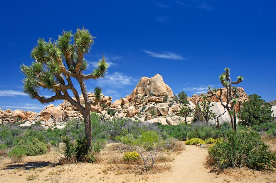
Native to the Mojave Desert in California, the iconic Joshua trees thrive in harsh conditions. As a species, they have survived for over 2.5 million years, with individual trees typically living to around 200 years.
However, climate change now threatens their survival, with rising temperatures and droughts putting them at risk of extinction – something that would have significant consequences for the broader desert ecosystem.
Drought and warming temperatures: Joshua Tree National Park, California, USA
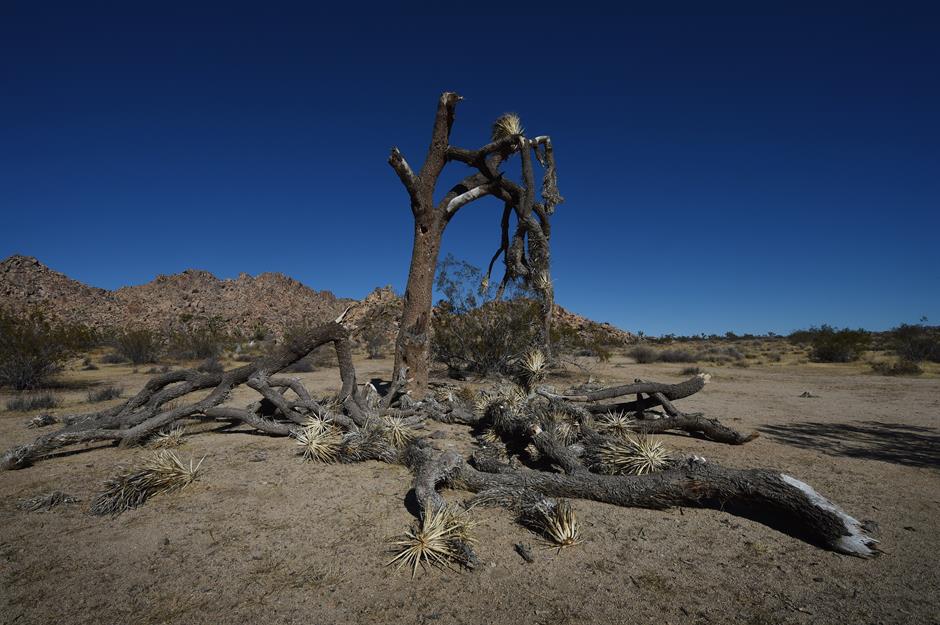
Joshua Tree National Park has become hotter and drier over the past century, with intense droughts devastating the spiny-armed trees, as rising temperatures prevent young trees from establishing the deep roots needed to survive in the harsh desert environment.
With the UN predicting summer temperatures could rise by 3°C (5.4°F) in the coming decades, some studies warn that these iconic trees may not survive much beyond the end of the century.
Receding lake: Lake Chilwa, Malawi
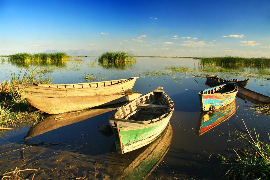
Lake Chilwa, Malawi's second-largest lake, is surrounded by some of the most densely populated areas in southern Africa. Recognised by UNESCO as a vital wetland and bird habitat, the shallow, closed lake is prone to seasonal water level fluctuations.
However, the frequency and extent of the lake's drying has increased dramatically, and its waters are becoming increasingly saline – both of which are linked to the impacts of climate change.
Receding lake: Lake Chilwa, Malawi
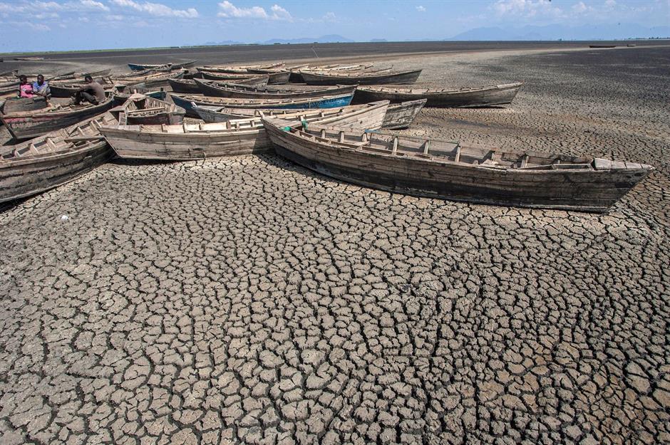
In 2018 the lake, located near Malawi's eastern border with Mozambique, completely dried up, leaving hundreds of fishing boats stranded on its cracked, dry bed. The receding water levels have been linked to persistent droughts, deforestation, intensive farming and the diversion of the lake's inlets for irrigation.
While heavy rains in early 2019 helped refill the lake, the threat of more frequent and prolonged dry spells continues to loom large, with communities in the surrounding areas still facing the ongoing impact of climate change.
Retreating ice cap: Greenland
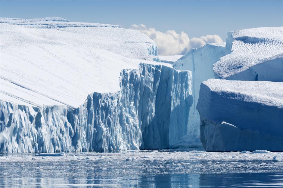
Around 80% of Greenland's surface is covered by the Greenland Ice Sheet, which began forming around 2.6 million years ago. This ice sheet spans approximately 656,000 square miles (1.7m sq km) and is the second-largest ice body in the world after the Antarctic ice sheet.
It plays a crucial role in global sea level regulation, but is extremely vulnerable to climate change – both warmer air and rising ocean temperatures are causing the ice cap to recede.
Retreating ice cap: Greenland
Greenland’s ice sheet is shrinking faster than ever. Research from the UK Centre for Polar Observation and Modelling found that between 2010 and 2023, the ice thinned by an average of 3.9 feet (1.2m), with around 563 cubic miles (2,347km³) of ice lost in total.
That’s a massive amount of meltwater pouring into the ocean, driving up sea levels and making coastal erosion, saltwater intrusion and flooding even worse across the globe.
Dying trees: Lebanon
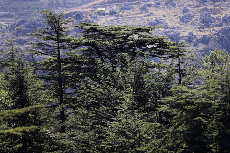
The centuries-old Cedrus libani, or Lebanon cedar, is featured on Lebanon's national flag, currency and airline logo. Historically significant, these trees – which have been referenced in ancient texts, including the Bible – are now at risk due to global warming.
The evergreen trees require adequate snow and rain for natural regeneration, but climate change has led to shorter and milder winters, affecting their growth, while deforestation further threatens their existence.
Dying trees: Lebanon
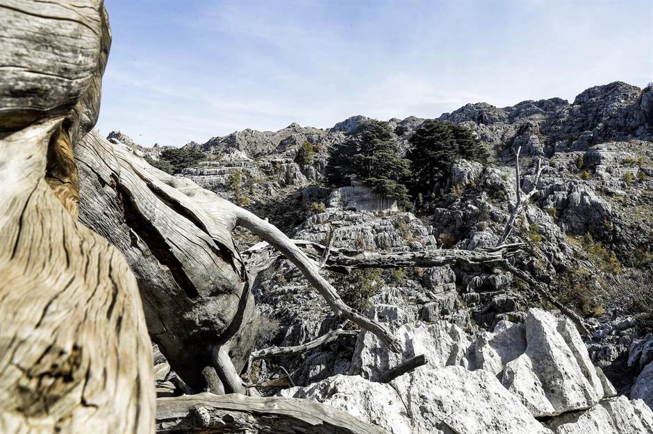
Hotter, longer summers have led to a boom in cedar web-spinning sawflies, which burrow into the trunks of Lebanon’s cedars and strip them of their needles. Since most of the country’s cedar forests are in UNESCO-protected areas, insecticides can’t be used to control the outbreaks.
This image shows dying trees in Jai, Mount Lebanon – one of several ancient reserves working to protect the forests that once covered much of the region.
Shrinking mountain: Kebnekaise, Sweden
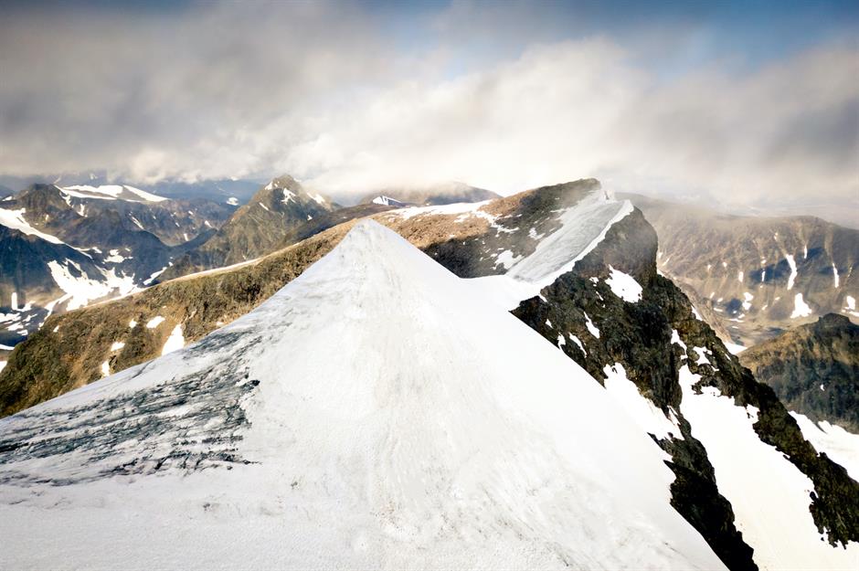
Sweden’s Kebnekaise mountain has two peaks – a glacier-covered southern summit and an ice-free northern one. Back in 1880, the southern peak was the tallest in the country, but things have changed.
By 2019, researchers found that the southern peak had shrunk to its lowest recorded height, making it 78 feet (24m) shorter than it was in the 1960s and 3.9 feet (1.2m) lower than its northern neighbour.
Shrinking mountain: Kebnekaise, Sweden
Record-breaking Arctic temperatures have caused the glacier to shrink at an alarming rate. Over the past decade, it’s been losing between 3.3 and 6.6 feet (1-2m) of ice each year, but in 2024, that jumped to 10.8 feet (3.3m) – the biggest drop in 30 years. With only 98.4 feet (30m) of ice left, if melting continues at this pace, it could disappear entirely within a decade.
Air pollution: Skopje, Macedonia
Skopje, the capital of Macedonia, struggles with dangerously high air pollution. A mix of smoke from home-heating fires, car emissions and coal-burning industries fills the air, while the surrounding mountains trap the smog over the city.
Beyond the serious health risks for residents, one of the biggest contributors – burning fossil fuels – is also a major driver of global warming.
Air pollution: Skopje, Macedonia
In 2018, Skopje was named the most polluted capital in Europe, with the highest annual levels of fine particulate matter in the air, according to the World Health Organization.
In 2022, emergency measures were introduced to combat the smog – but in 2024, Skopje was still ranked among the 10 most polluted cities in the world.
Shrinking glacier: Pasterze, Austria
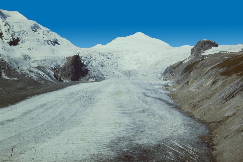
Located in the Hohe Tauern mountain range in the Austrian Alps, the Pasterze glacier – seen here in 1968 – is the country’s largest, stretching five miles (8km) long and three miles (5km) wide. It has been shrinking since the 1850s, but the pace has sped up dramatically since the 1960s due to global warming, with the glacier losing half its volume.
Shrinking glacier: Pasterze, Austria
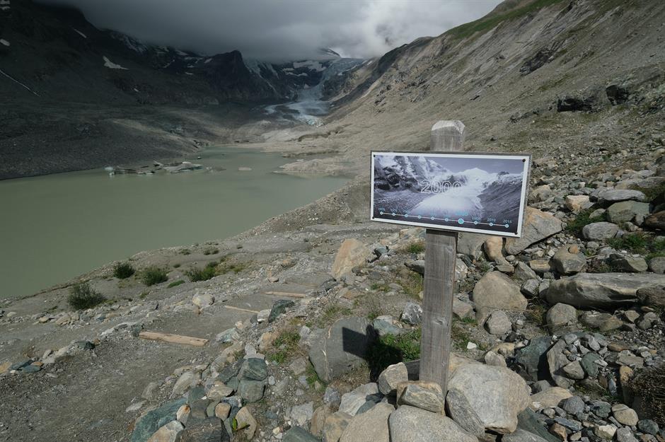
This 2019 image shows a sign marking where the glacier reached in 2000, with the actual ice now far in the background – and it’s only getting worse. In 2022–23, Pasterze retreated another 667.7 feet (203.5m), the largest recorded loss.
Alpine temperatures have risen nearly 2°C (3.6°F) in the past 120 years and could climb another 2°C in the coming decades. Many glaciers in the region have already shrunk dramatically and could vanish entirely by the end of the century.
Loss of sea ice: Kivalina, Alaska, USA
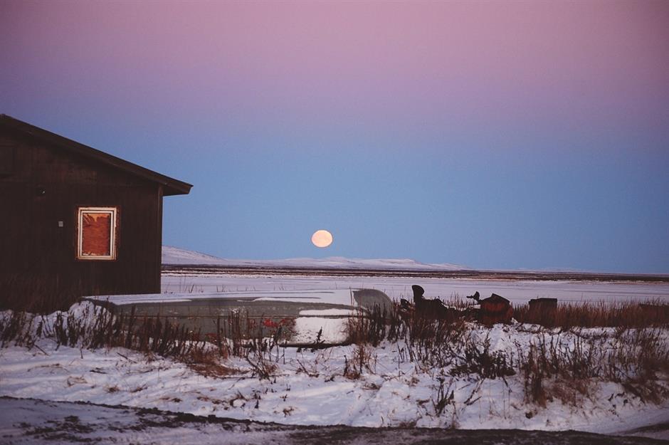
Many communities worldwide are feeling the impact of climate change, but few are as vulnerable as the remote Alaskan village of Kivalina. Perched on an eight-mile (12km) barrier reef between a lagoon and the Chukchi Sea, this Iñupiat community faces the growing threat of severe flooding, which could force them from their homes.
Loss of sea ice: Kivalina, Alaska, USA
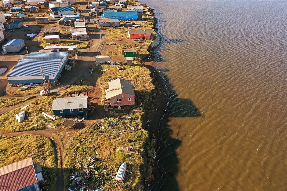
Melting sea ice leaves Kivalina’s shores exposed to storm surges and coastal erosion. Homes now sit dangerously close to the water’s edge, with little to protect them from the rising tide.
With the ice disappearing earlier each season, traditional hunting and fishing routes have become too dangerous to navigate, making it harder for the community to sustain its way of life. As a result, Kivalina’s population is slowly declining, dropping from 444 in 2020 to 397 in 2025.
Drought: Chennai, India
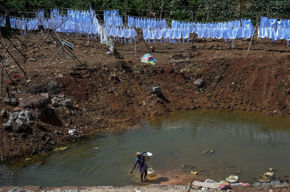
In 2018, exceptionally low rainfall led to a historic drought in Chennai, leaving many of the city’s reservoirs dry. Lake Puzhal (pictured), one of the main water sources, dried up along with three others. That year’s monsoon was also one of the driest on record, and with a population of 10 million, Chennai faced its worst drought in 70 years.
Drought: Chennai, India
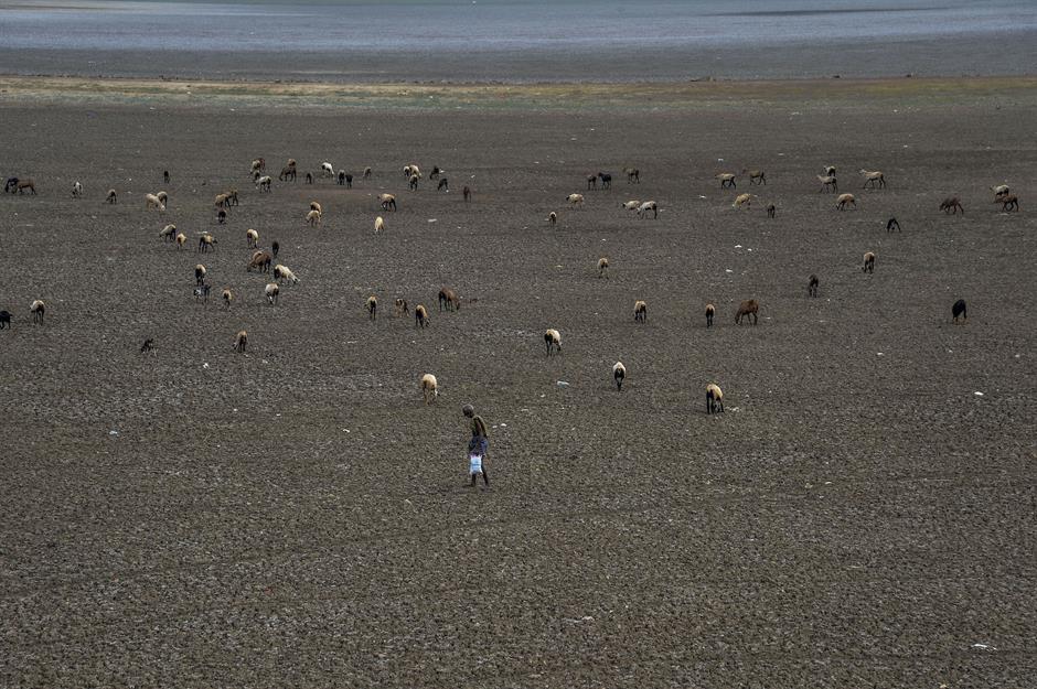
Lake Puzhal swings between a water-filled reservoir during monsoon season and a barren stretch of cracked earth in the dry months, forcing nearly five million people to rely on makeshift wells.
This image, taken in 2019, shows a shepherd grazing his sheep on the sun-scorched ground. While droughts and extreme heat are nothing new in India, rapid urbanisation is making cities like Chennai even more vulnerable to water shortages.
Dying trees: Montana, USA
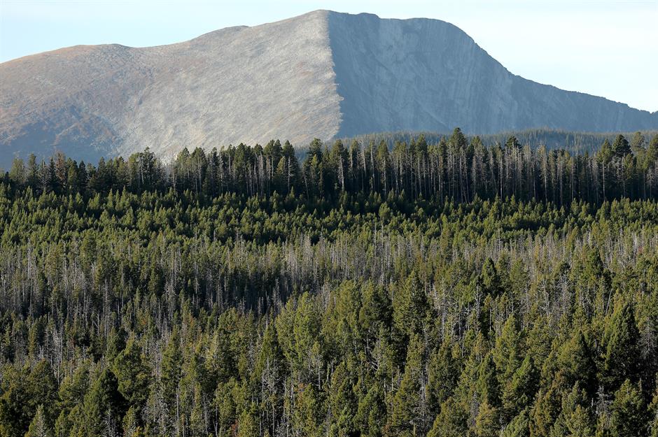
Forests play a crucial role in fighting climate change, absorbing carbon dioxide from the air. But across the world, native forests are being lost to deforestation and are becoming increasingly vulnerable as weather patterns shift. Montana’s once-dense forests are among those feeling the impact.
Dying trees: Montana, USA
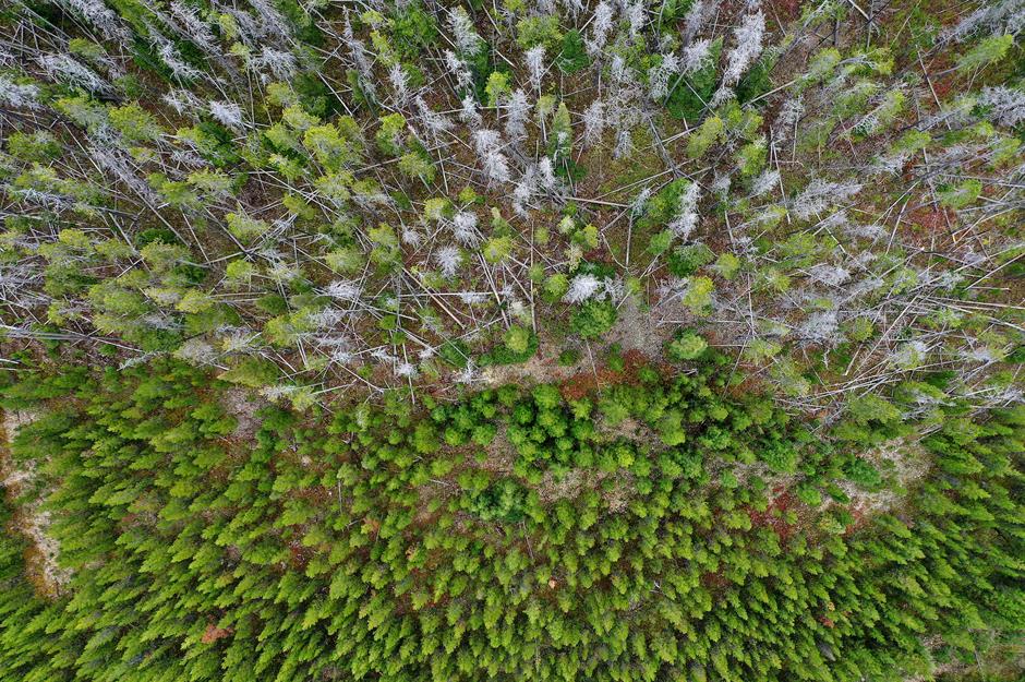
Hotter, drier summers in the Northern Rockies are putting forests like Montana’s Beaverhead-Deerlodge National Forest (pictured) at greater risk of wildfires, disease and insect infestations.
This 2019 image shows lodgepole pines killed by the mountain pine beetle, a tiny but destructive insect thriving in warmer temperatures. Drought-weakened trees are less able to defend against infestations, allowing the beetle to devastate forests across the western US.
Bushfires: Australia
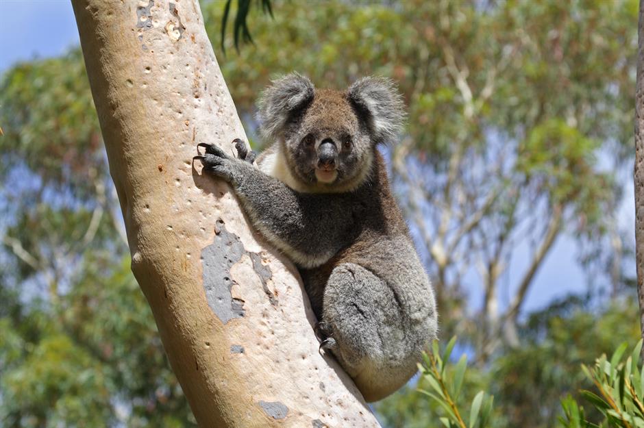
Bushfires are a part of life in Australia, often sparked by lightning rather than climate change alone. However, they’re becoming more frequent and intense as global warming takes its toll.
In 2019, Australia endured its driest spring on record, followed by record-breaking December heat. Extreme temperatures, prolonged drought and strong winds fuelled fires that burned over 11 million hectares (27.2m acres) from September 2019 to February 2020, until heavy rain finally doused some of the worst blazes.
Bushfires: Australia
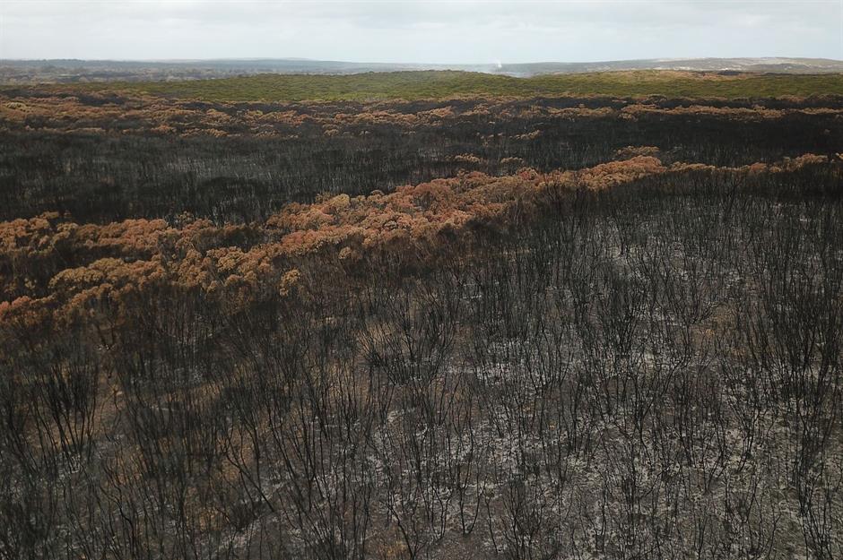
The scale and intensity of the infernos that swept down the country’s east coast in 2019 and 2020 have been unequivocally linked to human-induced climate change by experts.
In an open letter, 446 scientists warned of more frequent, extreme fire-weather conditions and an earlier fire season, especially in southern and eastern Australia. This image shows Kangaroo Island, where fires destroyed habitats and killed thousands of koalas and other native animals.
Coastal erosion: Norfolk, England, UK
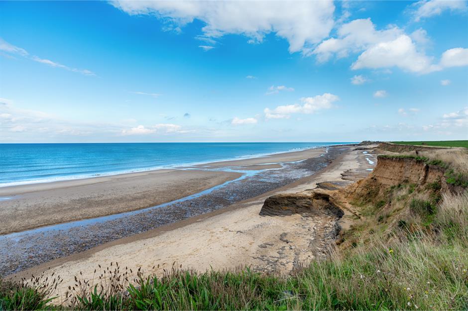
Low-lying East Anglia is just one part of the British coastline facing major changes as sea levels rise and extreme weather increases. More land will be lost to the sea as climate change increases the frequency and intensity of storms.
According to the Committee on Climate Change, sea levels around Britain could rise by at least three feet (1m) within the lifetime of today's children.
Coastal erosion: Norfolk, England, UK
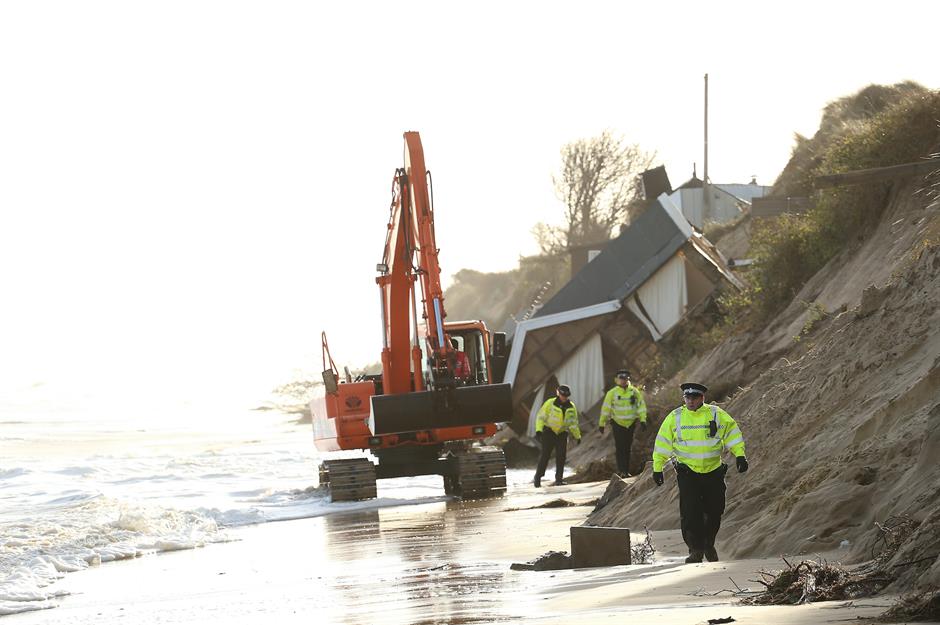
The residents of 20 seaside chalets in Hemsby, Norfolk had to be evacuated in March 2018 when high winds and waves threatened their cliff-edge homes, as great sections of the sand dunes were washed away.
More Hemsby residents were forced to abandon their coastal homes in March 2023, when high tides cutting into the sandy cliffs led to fears they may topple into the sea.
Hurricane Dorian: Bahamas
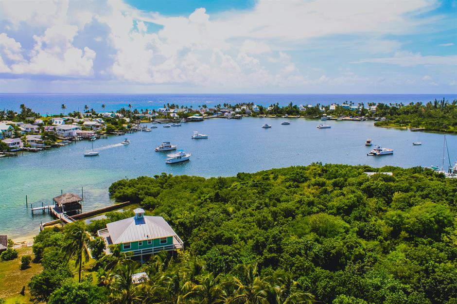
Tropical storms are a fact of life in the Caribbean. But 2019's Hurricane Dorian was the strongest ever to hit the Bahamas, as well as one of the most powerful storms to make landfall ever recorded in the Atlantic. Tropical storms draw their energy from ocean heat – so warmer ocean waters, heated up by climate change, bring stronger storms.
Hurricane Dorian: Bahamas
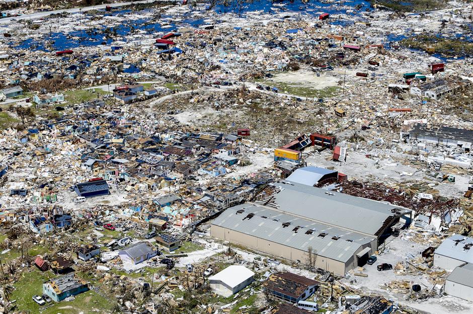
This aerial view of Marsh Harbour, Great Abaco, captures the devastation left by the Category 5 hurricane, which battered the island with 220 miles per hour (354km/h) winds for two days. Yet the most destructive force was the 20+ feet (6m) of storm surge and relentless rainfall.
Rising sea levels have intensified storm surges, while research suggests climate change is increasing the frequency of 'stalled' Atlantic storms. These slow-moving systems linger over one area, unleashing prolonged destruction and making them even more dangerous.
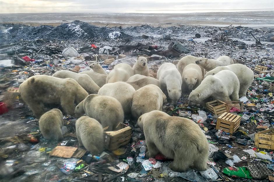
Arctic ice melting: Russia
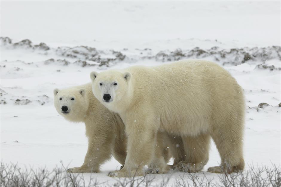
Polar bears are among the most visibly impacted animals by global warming, as melting Arctic sea ice forces them to spend more time on land, increasing competition for food and human encounters. These bears rely on sea ice to hunt seals, their primary food source.
According to the National Oceanic and Atmospheric Administration (NOAA), the Arctic Ocean's sea ice coverage at the end of the summer melt season in September 2024 was the sixth smallest on record, highlighting the ongoing decline of their critical habitat.
Arctic ice melting: Russia
Melting of sea ice in Arctic Russia has seen hungry and aggressive polar bears enter inhabited areas on the prowl for sustenance. In February 2019, the military town of Belushya Guba was 'invaded' by polar bears as they prowled streets and ransacked the rubbish dump for food.
According to reports, at least 52 bears were spotted on the streets from December 2018 until February 2019, leading to an emergency being declared in the town.
Water pollution: Patagonia, Argentina
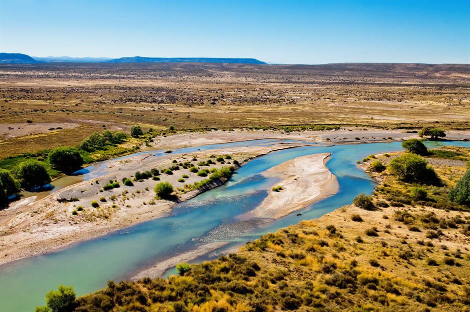
The Chubut River (pictured), which flows through Patagonia, Argentina, takes its name from the Tehuelche word 'chupat', meaning 'transparent' – a nod to its strikingly clear, bright blue waters. However, this river and others in the region face growing threats from fish factories and sodium sulphite, a chemical used to preserve prawns for export.
Local residents have long reported foul odors and environmental concerns, but in July 2021, the impact became impossible to ignore as the pollution visibly altered the river’s once-pristine waters.
Water pollution: Patagonia, Argentina
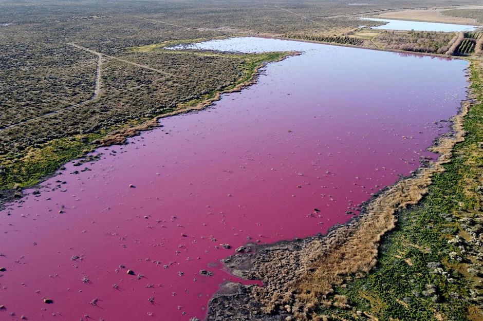
The Corfo Lagoon, fed by the Chubut River, turned bright pink, with environmental activists blaming waste from the nearby Trelew Industrial Park, which has caused similar discoloration in the past.
Before the incident, residents of Rawson, a city near the park, had protested by blocking trucks transporting processed fish in response to ongoing pollution concerns. Reports suggest provincial authorities permitted factories to dump waste into the lagoon, leading to the striking fuchsia hue, a visible sign of industrial contamination.
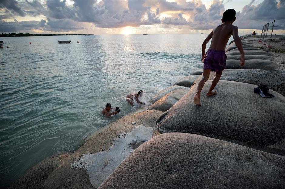
Rising sea levels: Tuvalu
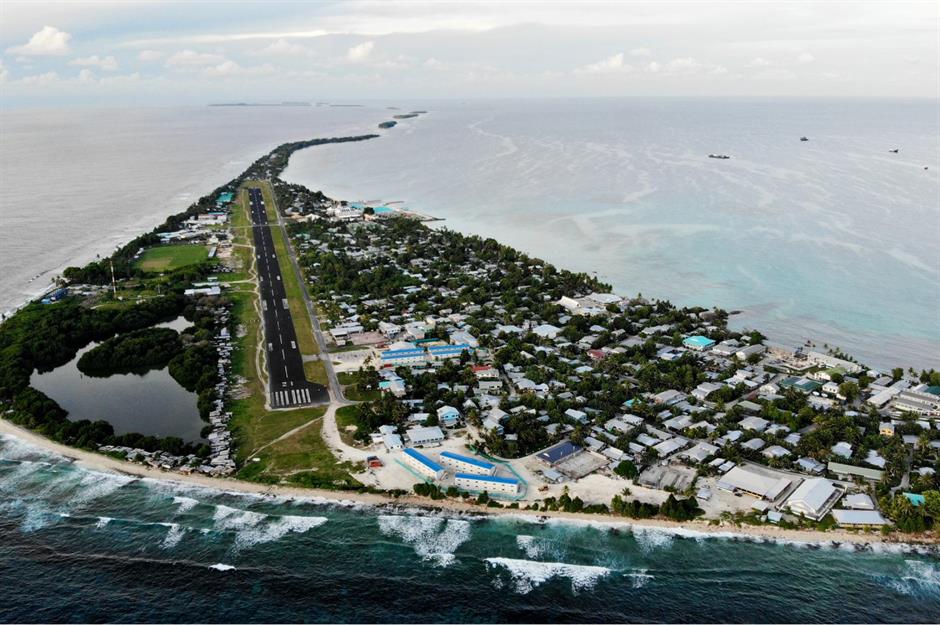
Tuvalu is on the front line of climate change, facing rising sea levels and destructive storms. The nine low-lying islands, between Australia and Hawaii, peak at just 16.4 feet (5m), while Fongafale, the main islet of Funafuti atoll, narrows to 66 feet (20m) at its slimmest point.
With groundwater contaminated by encroaching seas, Tuvalu now relies entirely on rainwater. However, declining rainfall and frequent droughts have led to chronic drinking water shortages, worsening an already fragile situation.
Rising sea levels: Tuvalu
Tuvalu has experienced a sea level rise of 5.91 inches (15cm) over the past three decades, one-and-a-half times the global average. By 2050, NASA scientists predict that daily tides will submerge half of Funafuti – home to 60% of Tuvalu's residents.
In 2023, Tuvalu signed a climate and security treaty with Australia, which will allow 280 Tuvaluans a year to migrate there, although residents are understandably concerned about the impact migration will have on their tight knit community.
Extreme heatwave: England, UK

In July 2022, the Met Office issued its first-ever red warning for extreme heat across most of England. Between 16-19 July, parts of the country recorded its hottest ever temperatures, and London's Hammersmith Bridge was wrapped in giant pieces of foil to stop it from overheating, as pictured here.
Extreme heatwave: England, UK
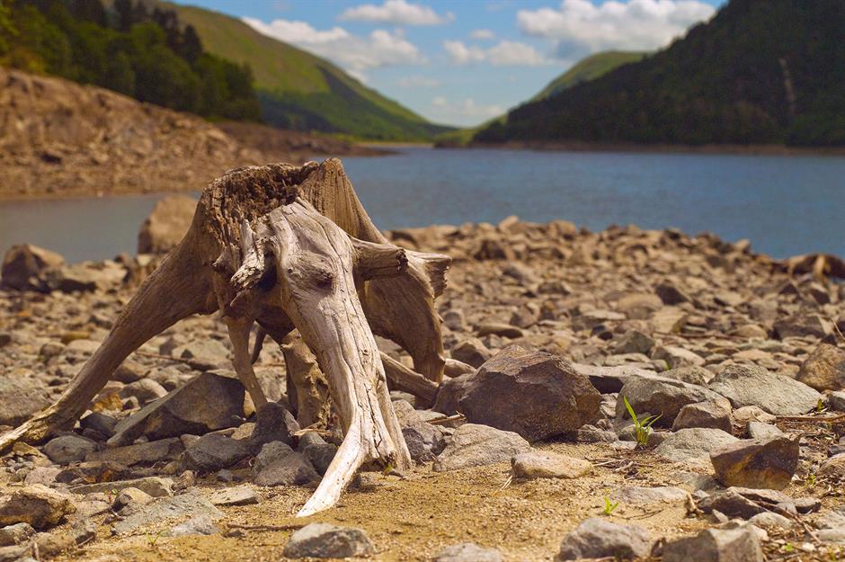
On 19 July 2022, a new UK and England temperature record of 40.3°C (104.5°F) was recorded in Coningsby, Lincolnshire. The heatwave marked a milestone in UK climate history, and heatwaves are forming a worrying trend of becoming hotter, longer and more frequent each year.
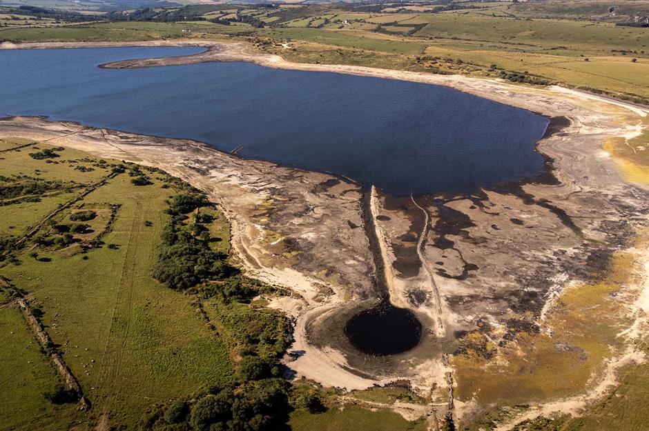
The Met Office also announced that 2022 had been England's driest year since 1976. Pictured here is Colliford Lake in Cornwall, which saw its lowest water level since 1995.
Drought: Europe
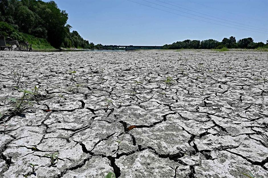
Following hot and dry weather, extreme droughts spread across over half of the countries in the EU during summer 2022. Affected harvests, lower energy production and emergency water handouts caused knock-on effects, such as an increase in food prices. Pictured here is Italy's River Po, which experienced its worst drought in 70 years.
Drought: Europe
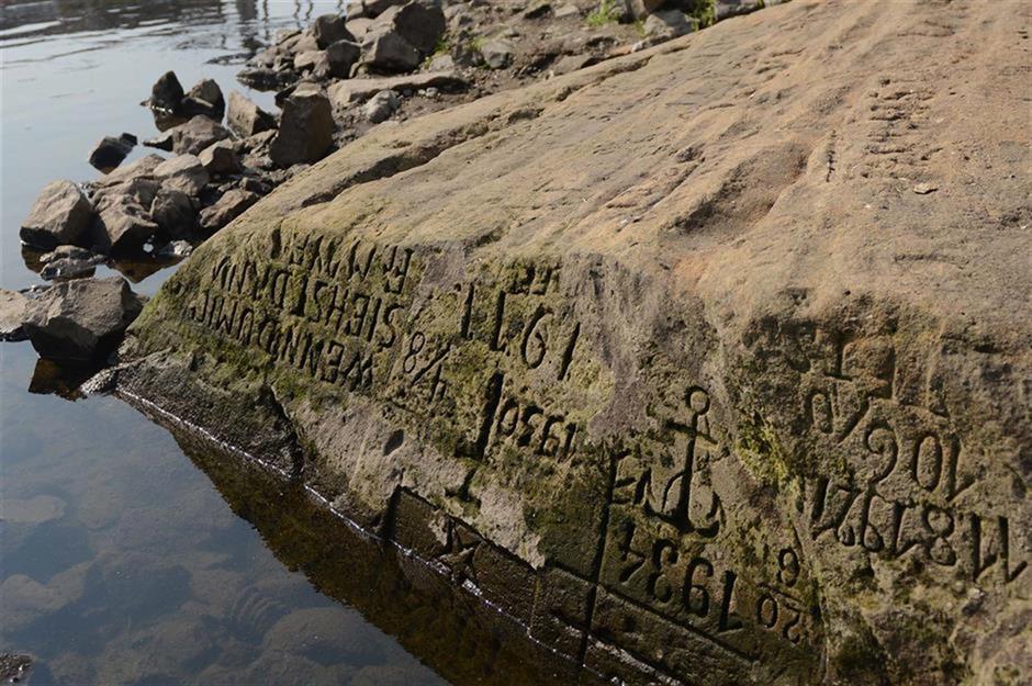
Extreme drought has caused 'hunger stones' to re-emerge in several European riverbeds. These rocks, engraved with historic low water levels, date back to the medieval era and serve as warnings – if visible, they signal looming famine. Pictured here is a 15th-century hunger stone in Děčín, Czechia, bearing an ominous inscription: 'If you see me, then weep'.
Devastating floods: Nigeria
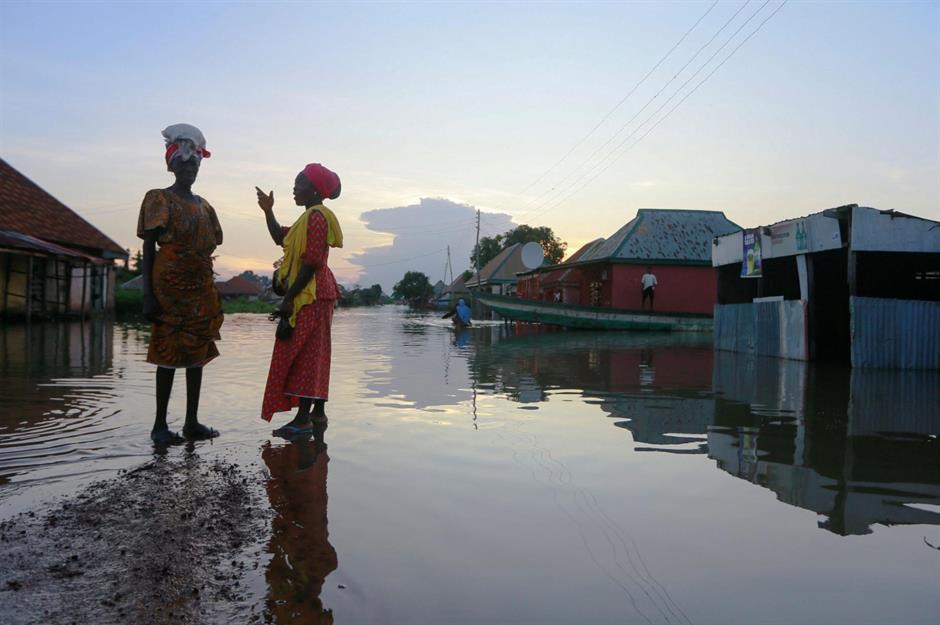
Deadly floods hit Nigeria between August and November of 2022. The tragic event resulted in over 600 deaths and caused some 1.5 million people to be displaced. A shocking study by the World Weather Attribution (WWA) revealed the floods were among the worst the region had ever seen, and were made 80 times more likely by climate change.
Devastating floods: Nigeria
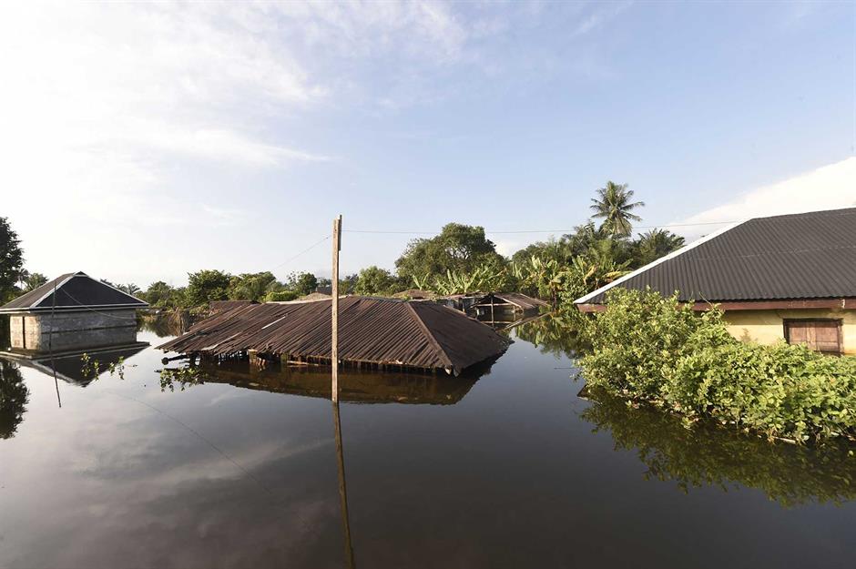
In August 2022, the Nigerian Meteorological Agency (NiMet) issued forecasts indicating an increased likelihood of flooding in areas along the River Niger and River Benue.
This prediction materialised as several states experienced significant rainfall, with some recording over 11.8 inches (30cm) within the month – exceeding the standard monthly average by more than 40%. The excessive rainfall led to widespread flooding and caused substantial damage.
Dust storms: Gulf states and Syria
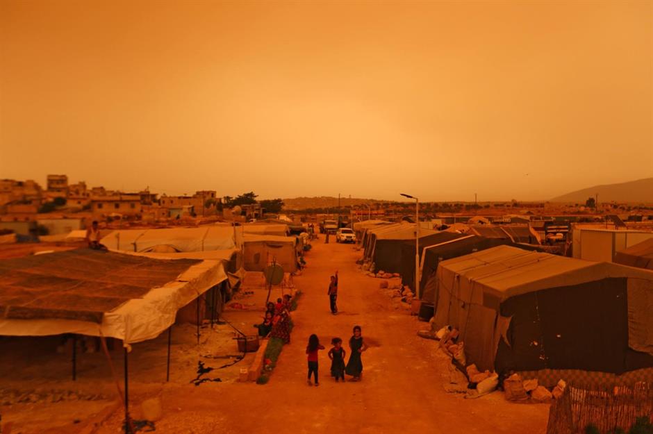
Severe dust storms hit Syria, Iraq and other Gulf countries between April and June 2022. While these are more common in late spring and summer, the phenomena arrived much earlier than usual, and affected a much larger area, which experts say is linked to climate change.
These dust storms typically occur in arid and semi-arid climates, when dust and sand particles are picked up by heavy winds and sent into the atmosphere, causing hazy, red skies (pictured here).
Dust storms: Gulf states and Syria
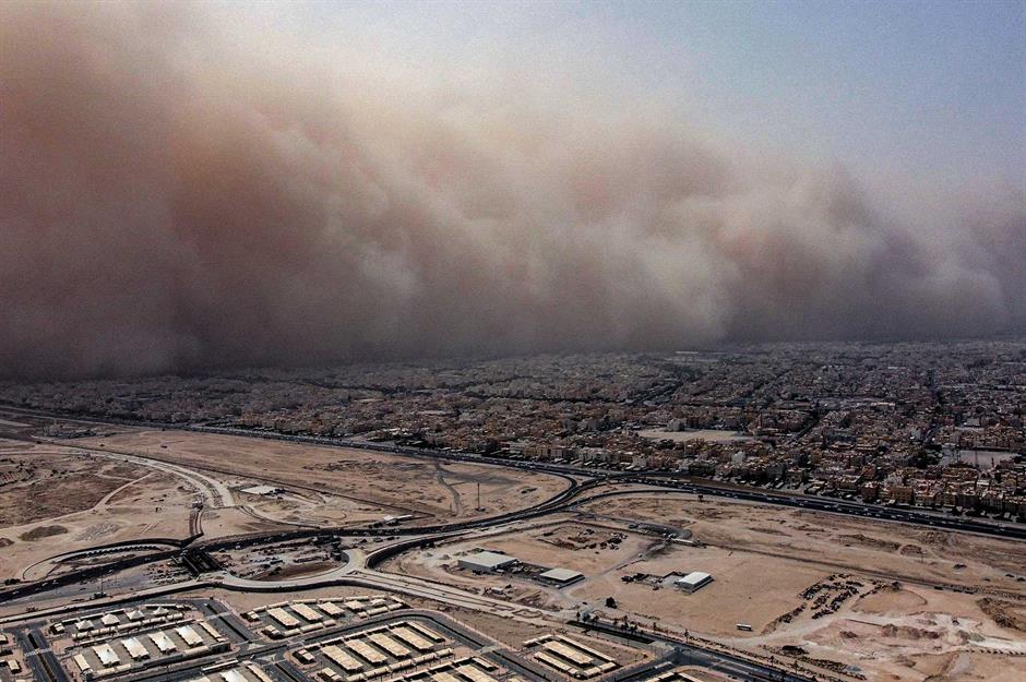
The devastating dust storms caused flights to be halted in places like Kuwait (pictured), while Saudi Arabia and the United Arab Emirates issued dust storm alerts. Hospitals in Syria were filled with patients unable to breathe.
An official from Iraq's environmental ministry said the number of the country's 'dusty days' had increased from 243 to 272 per year over the past two decades, but predicts this number could soon reach 300 days.
Drought: The Lake District, England, UK
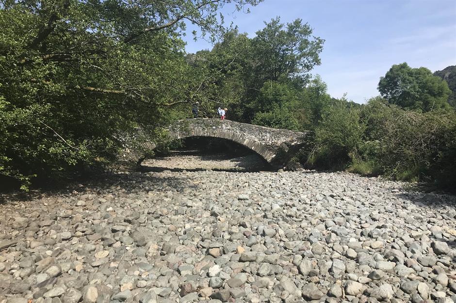
Stretches of the River Derwent in the Lake District's Borrowdale Valley (pictured) dried up in June 2023 after weeks of hot weather, resulting in devastating conditions for the wildlife that calls it home. Fish and insects were the worst affected, but this had a knock-on effect for the rest of the river's ecosystem.
Drought: The Lake District, England, UK
It was the third year in a row that the river in England's wettest area had dried up, raising fears for fauna in an area that is designated both a special area of conservation (SAC) and a site of special scientific interest (SSSI).
"Our nature is already under stress," said Ruth Mackay, a fisheries project officer. "When [drought] happens year after year, it becomes catastrophic for wildlife.” The fate of salmon was of particular concern, with the species already in decline nationally.
Flooding: Brazil
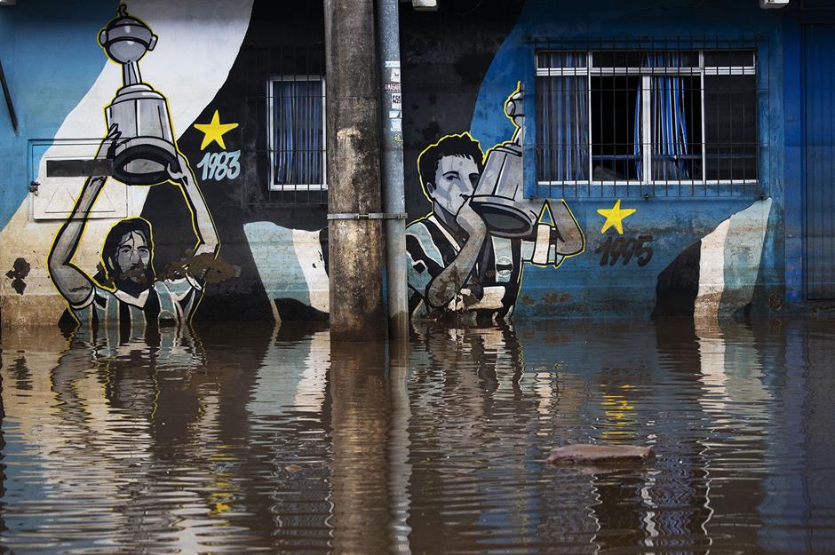
In May 2024 torrential rain lashed the southern Brazilian state of Rio Grande do Sul, flooding the capital city, Porto Alegre, and causing widespread death and destruction. Climate scientists believe a heatwave early that month had blocked a cold front, leading to record-breaking rainfall.
Described as one of the worst climate disasters in Brazil's history, no part of the city was unaffected. Floodwaters and mud rendered football stadiums in Porto Alegre (pictured) inoperable, leaving the local clubs, Gremio and Internacional, unable to train or play.
Flooding: Brazil
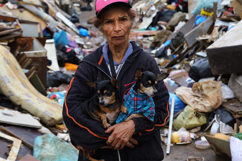
With the city submerged under 1.5 billion cubic metres of water – enough to supply New York City for more than a year – it was the poorest people of Porto Alegre who suffered the most. More than 183 people lost their lives and more than 600,000 were displaced.
Here we see retiree Jandira de Campos, 70, with two dogs she rescued in the Vila Farrapos neighbourhood. Surrounded by tonnes of debris, her image is a poignant reminder of the scale of such disasters and the impact they have on everyday people.
Wildfires: Spain and Portugal
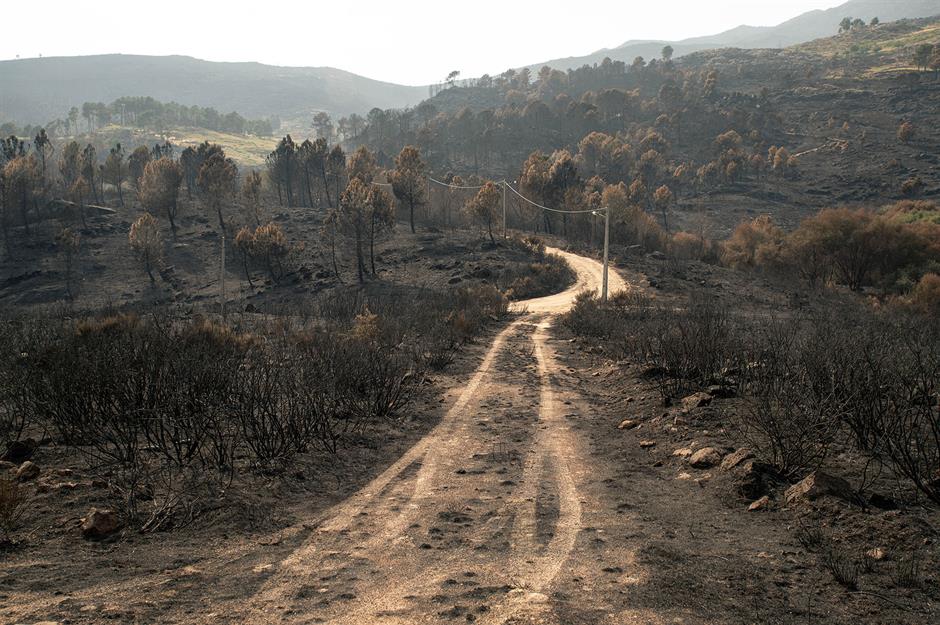
The summer of 2025 saw the Iberian Peninsula suffer a terrifying heatwave, with temperatures regularly exceeding 45°C (113°F). More than 1,500 heat-related deaths were reported in Spain alone.
The record temperatures also fuelled Spain's worst wildfire season in three decades, with flames destroying over 988,000 acres of land. This photo of the aftermath of a wildfire in Unhais da Serra shows that Portugal was not spared, suffering a record burn of 667,000 acres.
Wildfires: Spain and Portugal

The fires triggered the largest known deployment of the EU’s civil protection firefighting force, and with rising average temperatures climate scientists predict that things are only going to get worse. Perversely, the fires themselves are adding to the problem by releasing even more planet-warming carbon dioxide gas (CO2) into the atmosphere.
Locals are becoming increasingly frustrated – and terrified – by the lack of action on climate change and the devastating fires it is fuelling. Here we see protestors holding placards reading “No more fires” in Verin, Spain, an area that had suffered a 16-day-long heatwave that summer.
Read on to discover the incredible places that will be underwater by 2050
Comments
Be the first to comment
Do you want to comment on this article? You need to be signed in for this feature